Dji datalink

Cletus

Member
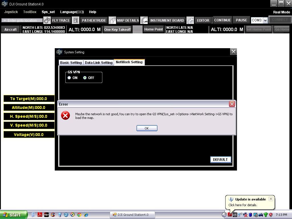
DJI Ground Station 4.0.6 was working perfectly for me (5-waypoint Wookong-M). This morning I updated to 4.0.7 and Google maps won't load. I keep getting the following message, even if I do as it suggests and try the VPN:

Maybe the network is not good, You can try to open the GS VPN(Sys_set->Options->NetWork Setting->GS VPN) to load the map.

I am really not happy with this development. Can anyone shed some light on this?

Here's s screenshot:
screenshot_zps2240284e.jpg
 
Last edited by a moderator:

gtranquilla

RadioActive
GCS is intended for MR autonomous control with the capability of uploading new waypoint positions from time to time.

IMHO - The joystick is useful for simulation mode only......
With real flying, it serves no useful purpose other than to fly in manual mode which is not the main reason why one would buy GCS.


Hey Guys, Been playing with DJI in simulation mode and can invoke Keyboard control but not Joystick control.
I can go in and select the joystick, configure it and calibrate it. I just cannot invoke joystick control (Logitech Extreme 3D Pro).
Any Ideas???

ToughbookDJI_zps31e715de.jpg
 

Cletus

Member
EUREKA!!!
banana.gif

Found the problem! Turned out to be simple as, Google Earth not liking my Video Settings!
You have no idea how many hours it took and the number of times I screwed with XP install, to finally track down this simple issue!
4_17_3.gif
 

Tahoe Ed

Active Member
EUREKA!!!
banana.gif

Found the problem! Turned out to be simple as, Google Earth not liking my Video Settings!
You have no idea how many hours it took and the number of times I screwed with XP install, to finally track down this simple issue!
4_17_3.gif

What did you change your Video settings to??? Finding a solution helps you but unless you share it helps no one else. Quid pro quo bro.
 

Cletus

Member
Yeh, sorry about that Ed, I guess the excitement got the better of me :)

Very unscientific I do confess. But, this morning, in lieu of smashing the laptop, for no real reason I just started screwing-around with Google Earth and poking at all the Display Properties / Settings of XP, when suddenly, a Google Map appeared on the screen! ......,ok, maybe I'm on to something here, I thought.
Closed-out Google Earth and started DJI Ground Station, and sure enough, there it was!
So, for the Panasonic Toughbook CF-29 running Win XP Pro, it's: Digital Flat Panel, 1024x768, 32-bit
Simple as that ...........go figure!
eusa_doh.gif


Oh, and you may or may not need to run this Google-Earth fix http://www.flyingcameras.ca/download..._djigs_fix.zip
......and yes, I did shut-down and restart the computer a couple times and it still works
rofl.gif
 
Last edited by a moderator:

buddyrama

Member
"Waypoint time exceed!" problem

i can't figure this one out.

I start my mission and the copter is ascending to the first waypoint "0" at 106 meters, which is a "stop and turn". The weight time is 0. I use that for my first point because it allows the copter to reach my mission altitude before it continues. This allows for a consistent altitude for my gis mapping.


However, a few feet before it hits the first waypoint "0", the copter stalls in a hover for about 30 sec., about 5m from the waypoint, until a message appears on the ground station editor saying, " waypoint 0 time exceed!". :upset:
The copter then engages the remaining waypoints 1-4 with adaptive bank turns without a hitch. Can someone explain what is going on. This has not happened with the other missions i've flown.
I'm not sure what the cause is.


Cheers,

buddy.
 

buddyrama

Member
First let me say my objective is to fly GIS missions. I'm trying to have a consistent altitude for my data. I need to be at altitude at the waypoint when waypoint 0 starts. Is there a consistent way to do this?


TESTS-
I did some more tests yesterday. It seems it only happens with my first waypoint with a stop and turn. I changed the wait time to default(3). What I noticed was that as it approaches the altitude of 106m it slows down at about 98m as if it is trying to reach the altitude and first waypoint exactly. However this last bit moves so slowly that it exceeds the time limit and moves on to the next points. I even flew the rig manually to the altitude and then pressed "go". Even though it was at altitude, it barely moved forward towards the actual point. In this case though it eventually hit the point, but it took 30 seconds to move 10 feet with Stop and Turn.


When I set all turns to adaptive. The rig did not fly to the first waypoints altitude before continuing. It seemed to reach the Lat and Long first, but not the exact altitude. It then moved on to the second waypoint eventually reaching altitude mid-flight.


It seems my most successful mission was when all the turns were adaptive and I flew the rig to altitude then pressed, "go". However, I prefer that the first point to be an exact start, which is why I thought Stop and turn was appropriate for the first waypoint


I'm just looking for the consistent repeatable way to get this data. Any ideas or protocol to employ? Perhaps my vertical and horizontal speed needs to change? Vertical is currently at 2ms. My horizontal is at 4ms.


thanks for your insight,


best,

buddy
 

bortoman

New Member
hi, i'm getting the "handshake failed" message, and can't figure out how hof to solve it...

i've tried several times on different pc's / laptops, what am i doing wrong?

here my steps:
- plugging in ground unit via usb
-> "DJI USB Virtual COM" is shown correctly in device manager
- turning on my s1000
-> LINK led turns green on (air and ground unit)
- trying to connect Ground-Station software to the correct com port
-> FAILS!
frown.gif


the distance between air and ground unit is ca. 5-10m...
 

leofuica

Member
Hi...

Maybe your turn ON with oput the antenna and bourn out the TX, or try to change for another Datalink equal with your Dealer and try, fabric failure is and possibility...
 

gtranquilla

RadioActive
Turning on transmitter output section without antenna connected could damage output section of the transmitter.
Or Transmitter defective - try to exchange defective unit with your DJI dealer.
Possible hardware failure!

Espanol: Leo, Computer Übersetzern oft nicht effektiv zu arbeiten.

Einschalten Senderausgangsschnitt ohne Antenne angeschlossen Könnte Ausgang des Senders Abschnitt beschädigen.
Oder Sender defekt - versuchen Sie, Ihre defekte Gerät mit DJI Händler umtauschen.
Mögliche Hardware-Fehler!

Portugese:
Leo, tradutores de linguagem de computador muitas vezes não conseguem trabalhar de forma eficaz.

Ligar seção de saída do transmissor sem antena ligada pode danificar a saída da seção do transmissor.
Ou transmissor com defeito - tente trocar a sua unidade defeituosa com traficante DJI.
Falha de hardware possível!
 
Last edited by a moderator:


hi, i'm getting the "handshake failed" message, and can't figure out how hof to solve it...

i've tried several times on different pc's / laptops, what am i doing wrong?

here my steps:
- plugging in ground unit via usb
-> "DJI USB Virtual COM" is shown correctly in device manager
- turning on my s1000
-> LINK led turns green on (air and ground unit)
- trying to connect Ground-Station software to the correct com port
-> FAILS!
frown.gif


the distance between air and ground unit is ca. 5-10m...


I found re flashing the firmware on all devices solves the issue. ie the air end and ground end as well as the bluthooth module.
 

bortoman

New Member
Hello everyone,
after loosing dozends of hours trying to figure out the problem i found out that the builder connected the Datalink to CAN1 on the A2 instead of CAN2...
Switching to the right CAN solved the issue!
Capture.png
 

bortoman

New Member
hi, finally the data link is working and i was able to make some test-flights, i have set a route with the photogrammetry tool and the drone is flying the route but it doesn't take a single picture!

Setup:
- S1000
- A2
- Zenmuse with 5DMk3
- PC Ground Station 4.0.10

taking pictures with the shutter control on the remote works, but from the ground station there is no way to trigger...


Top