You are using an out of date browser. It may not display this or other websites correctly.
You should upgrade or use an alternative browser.
You should upgrade or use an alternative browser.
DJI GPS --is doing circles---Help??
- Thread starter jascamera
- Start date
OneStopRC
Dirty Little Hucker
Declination, your GPS has nothing to do with the circles, more like the Declination is off in the area you are flying in. You have to move the GPS head in the correct direction to set your Compass to the correct degrees, if set wrong, you will toilet bowl.
See here for your declination http://www.ngdc.noaa.gov/geomag-web/#declination you set it by moving the arrow in the direction you require. The front of your quad, then move your GPS head with the little arrow mark where the wire comes out, you move it either to the left of the front of the quad, -° or right +°.
This is mine,
As you can see 9° which is a positive number, so I would rotate my head 9° to the right of the front of the quad. I printed out a protractor
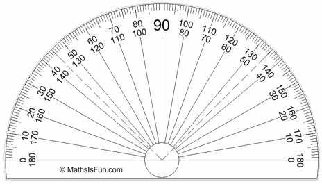 and used it to gauge my declination.
Some good information on YouTube also...
Hope this helps you....
See here for your declination http://www.ngdc.noaa.gov/geomag-web/#declination you set it by moving the arrow in the direction you require. The front of your quad, then move your GPS head with the little arrow mark where the wire comes out, you move it either to the left of the front of the quad, -° or right +°.
This is mine,
| ||||
|
As you can see 9° which is a positive number, so I would rotate my head 9° to the right of the front of the quad. I printed out a protractor
Some good information on YouTube also...
Hope this helps you....
Last edited by a moderator:
Declination, your GPS has nothing to do with the circles, more like the Declination is off in the area you are flying in. You have to move the GPS head in the correct direction to set your Compass to the correct degrees, if set wrong, you will toilet bowl.
See here for your declination http://www.ngdc.noaa.gov/geomag-web/#declination you set it by moving the arrow in the direction you require. The front of your quad, then move your GPS head with the little arrow mark where the wire comes out, you move it either to the left of the front of the quad, -° or right +°.
This is mine,
Latitude: 39° 36' 40" N Longitude: 79° 53' 58" W
Date Declination 2013-11-08 9° 8' 16" W changing by 2.1' W per year
As you can see 9° which is a positive number, so I would rotate my head 9° to the right of the front of the quad. I printed out a protractorand used it to gauge my declination.
Some good information on YouTube also...
Hope this helps you....
Nice visual explanation.
Last edited by a moderator:
Deanot,
GPS hold is perfect at hover now. But once I start moving forward, or backward, the aircraft will do a circle before coming back to a gps hover. Normally, I would be happy with the result, as I normally don't use GPS hold.
But this new copter will be using with waypoint, so I would like to perfect the GPS hold before going forward to the waypoint. My inclination should be 13.55 in SF and I used the gauge and couple variant degrees, seem to yield similar results.
Anyone have any idea where to look into?
Quantumlight
Member
Hi Just as a tip is to read the naza manual. It have great visual diagrams and solutions.
But in essens if the multirotor is doing toiletbowl in left circle twist your gps unit to the right if it is cickeling the other way twist to counteract. Just a tad no more then a few degrees.
Then it also usually solve the issue of the multirotor not going straight when you switch over to IOC
But in essens if the multirotor is doing toiletbowl in left circle twist your gps unit to the right if it is cickeling the other way twist to counteract. Just a tad no more then a few degrees.
Then it also usually solve the issue of the multirotor not going straight when you switch over to IOC
OneStopRC
Dirty Little Hucker
When you calibrate your GPS with the gps dance, you are actually calibrating the compass. Make sure when you do this, you're away from metal buildings, iron poles, cellphones and some jewellery can effect the compass. Recalibrate away from everything, do it in an open field and try again. When you also start flying, make sure you have enough satellites and try again.
Sent from my SAMSUNG-SGH-I337 using Tapatalk
Sent from my SAMSUNG-SGH-I337 using Tapatalk
Thanks guys,
I got it holding nicely now. It actually takes more like 30 degree to stop all toilet bowel symptoms.
ya that was what I would say, my magnetic deviation where i live is a -11 degrees, but when I set my GPS I am probably offset by 25 degrees.
In the past and still, the way I figure it out I will take off and fly the copter straight forward, what ever the direction the it starts drifting in the flight path. I will land the copter and rotate the compass in the opposite direction. Repeat the process until the copter flies straight when the transmitters stick is in a straight forward direction. There was a time when my copter would fly straight and I did not have to make any correction on the GPS orientation, but that changed during one of the firmware upgrade, around 5.16 time.
Fly well my friends.
smackenzie
Member
Its changing 2.1' (minutes) per year. that means, after 30 years it will change by a degree. So, once set, I think we're good for about 15 years or so… :tennis:.
A couple years ago, our local airport changed it's main runway from 30 (300 degrees) to 31 (310 degrees). First time in its history, but they don't need to do it often...
A couple years ago, our local airport changed it's main runway from 30 (300 degrees) to 31 (310 degrees). First time in its history, but they don't need to do it often...
Last edited by a moderator:
OneStopRC
Dirty Little Hucker
One thing I have noticed is a difference between websites, noaa shows mine as 9° which is a positive number, while http://magnetic-declination.com/ shows me as -9°. So I wonder which is accurate now? You would think the NOAA site would be. Just looked at another site and it tells me +9°.... But looking at the following information, relative to my location I should be -9° and not +9°.
I would strongly urge anyone to read this information and take it in, it does explain in detail with some graphics to show you more about Magnetic Declination. If you fly by GPS/Compass, you should be understanding why this is important to your flights.
Source: http://www.sco.wisc.edu/mapping-topics/magnetic-declination.html[h=2]Using Magnetic Declination[/h]The line of 0° declination currently passes through Wisconsin. Keep in mind that when you are located west of the 0° line-of-declination, the declination is east (or positive). When located east of the 0° line, the declination is west (or negative).
To translate the difference between the geographic and magnetic meridian, the angle of declination must be subtracted from the magnetic north reading. For example, Eau Claire, located west of the 0° line, has a magnetic declination of approximately 1° 30' east (as of 1998). To correct a magnetic compass reading to true north when west of the 0° line, the declination value should be subtracted from the magnetic north reading. When east of the 0° line, you should also subtract the declination from the magnetic north reading, but remember that in this case the declination value is negative. Subtracting a negative number will essentially result in adding the declination value to the magnetic north reading. Where the magnetic declination is zero, a compass needle will point true north.
I would strongly urge anyone to read this information and take it in, it does explain in detail with some graphics to show you more about Magnetic Declination. If you fly by GPS/Compass, you should be understanding why this is important to your flights.
T J Gilbert
Devil's In The Details
Declination
DJI maintains that compass declination is accounted for automatically...
http://www.rcgroups.com/forums/showpost.php?p=22527634&postcount=15039
Please excuse my linking to another forum...
Most GPS/Compass interference issues seem to be related to conditions specific to your flying site or interference from other components on your airframe...
DucktileMedia
Drone Enthusiast
Wow! Dji actually responded to a post on a forum? Never seen that before.
blade strike
Member
Well, it don't work. lol
Are you sure you have your GPS location settings correct in the software?
smackenzie
Member
One thing I have noticed is a difference between websites, noaa shows mine as 9° which is a positive number, while http://magnetic-declination.com/ shows me as -9°. So I wonder which is accurate now?
Here's how my flight instructor showed me how to look at it:
visualize a compass rose. If your local declination is degrees east, your magnetic compass north is east of true north. To fly true north, subtract the declination from your magnetic heading.
If your local declination is degrees west, your magnetic compass north is west of true north. To fly true north, add the declination to your compass heading.
If you saw an FAA sectional chart, look at the compass rose printed around a navaid such as a VOR. Here's an example...
http://www.footflyer.com/PPGBibleUpdates/Chapter08/Images/DC-SectionalChart.jpg
Looking at the compass rose in the lower right hand corner ( it's a pretty busy chart, but look for the Nottingham VOR), you see that magnetic north (0 degrees, marked by an arrow) is a little to the left of true north (straight up).
In that area, magnetic declination is 11 degrees west, so to fly true north, add 11 degrees to compass heading.