Dji iOSD Application Good News if you own one..

VINHEX

Member
I've spent a couple of days creating an application to use the DJI iOSD Data.. This is not fully alpha tested yet.. But if you are interested in a copy in a week or so PM me and I'll send you the link.. Free of course... (at the moment LOL)

If interested will show how you load the data in and get the information..

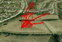
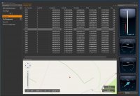
This will show you at a click where you was flying, GPS Coordinates as well as Altitude, yaw, pitch and roll. It will fly you through your data showing on the map you location and where you were flying.. You can also export this data to Google Maps to see your complete flight path..

View attachment 12055View attachment 12056
 

Attachments

  • FlightLog GMaps.jpg
    FlightLog GMaps.jpg
    143.2 KB · Views: 638
  • Screen Shot.jpg
    Screen Shot.jpg
    143.1 KB · Views: 653

Kilby

Active Member
I'll help you test that if you like. I'm a software engineer myself, so I know how valuable good testing feedback can be.

-Terry
 

VINHEX

Member
Thanks Terry,
Will send link over.. Just a few issues on the gauges which I want to get right.. also want to change the view on them as well.. Will PM once completed


SMP

Member
Just installed the iOSD on two birds, very interested in your App! Unfortunately I'm the opposite of the chaps above. "Stone Cold Idiot Proofing Guy". If I can use it, EVERYONE can!


yakjock

Member
Sounds good I dont have my WKM bird back up yet but I will be flying the iOSD in the naza when the new PMU comes out so would like to try it on that.
 

bnt276

Member
Love to try it on my NAZA-M. My PMU-V2 is on the way and I will be setting up.
Nice UI design as well.

CHEERS

Brent


VINHEX

Member
Can you PM guys if you want to try as I don't want to miss anyone in the comments thanks..


Vin
Hexacrafter HC650, DJI WKM, DJI DataLink 2.4Ghz, 3s 3300, 3s 5000, Aeroxcraft Landing Gear, Xoar 12x6 props, Spektrum DX8, AR8000 Receiver
TM1000, Fatshark Attitude SD, Sony Exview Had II CCD 650 Line Sony Effio-E
Fatshark Spironet Antenna's, DJI iOSD
 

bnt276

Member
Now if we could plot points from google maps - input into the NAZA - watch it fly.

Wouldn't that be something. :)


paktazh

Member
lets find a way to get the way point serial Number or code to use the 50 way point since you guys r S, E that will be great
 

VINHEX

Member
There is no time stamp coming from the iOSD at the moment... but will add if they release in the file.. Not for off a release, just tweaking the code a little.. I've just carried out the update on the firmware but not done any flights.. Will try and get a flight in this evening to see if the update has not changed any data..

Will keep you all posted.. Going to add some google map choices as sell absolute, relative to ground, flat path ect..
 

srbell

Member
It was promised that time stamp data may be included with firmware 5.23 and GPS Exporter 1.2 but all that change was the data frequency. Went from 50hz to only at shutter activation points. Unfortunately the way the shutter works on the Zenmuse and how it works with GCS is incompatible. GCS is really software for the Ace One as each shutter point is two actions to move a servo. This of course confuses the Zenmuse, sometimes getting two images per action but other times one lol! Sure would be nice to sync up these photos for photogrammetry work without having to use a separate data logger. Currently I've got a retired APM 2.0 autopilot mounted to the S800 for this function. Seems silly to use another autopilot to do what DJI advertised.


VINHEX

Member
Guys, I would just like to add a note... This is not a hac into any software.. This is using the data-reader GPS exported tool that DJI provide and I'm just using the data to create my own app.. for what I would like...


VINHEX

Member
Please read: first...

This is an aplha test application.. And if you install it's at your own choice.. There maybe bugs but post them on here and ill try and support the best I can.. I can't support personal issues if something is not working its be added as a favour...

Instructions..
1: you need to download the GPS exporter from DJI site http://www.dji-innovations.com/download/wookong-m-waypoint-downloads/

2: copy the files install from https://www.dropbox.com/sh/lvu5et4y8jkof88/KbB_mDdh2C please copy do not drag and drop as this will remove the files from the server.

3: install google earth download from google if not already.

4: use the DJI GPS converter to convert your iOSD dat file into a txt format..

5: drag and drop the file into the black area above the map. Or use the menu file open and select the converted file.

6: click on. Any line in the data and this will point to that location and data select as you wish..

Flight:

Select start flight this will run through your flight showing you in the map below.. If you raise or lower the number on the zoom in the left menu it will zoom in and out.. The flight will continue until it reaches the end or your select stop flight..

Export..
Select export to google maps and save the file on your desktop.. Double click on file and it should open in google earth..

BUG.. I've had some issues but I think it's google earth that when finished google earth doesn't close down correctly only happens now and again.. But if does ie you double click on the file again and nothing happens you need to kill the service in manager on your pc..

Have fun load some examples up and again please it's install at own risk..


Vin
Hexacrafter HC650, DJI WKM, DJI DataLink 2.4Ghz, 3s 3300, 3s 5000, Aeroxcraft Landing Gear, Xoar 12x6 props, Spektrum DX8, AR8000 Receiver
TM1000, Fatshark Attitude SD, Sony Exview Had II CCD 650 Line Sony Effio-E
Fatshark Spironet Antenna's, DJI iOSD
 

HeinzABF

Member
Hi Vin,

downloaded all. I have tried the FLY 230.txt file to open in GE. But GE takes no txt files.

What am i doing wrong?
Heinz
 

Top