Mactadpole
Member
Howdy All,
As requested I will fill you guys in on my background and intended uses for multirotor copters. Currently, I am a PhD candidate at Texas State University in the Department of Biology. My primary interest is in Batrachology (study of amphibians). I have been doing amphibian research in Amazonia since 2000. I am also Founder and President of a non-profit research organization for tropical amphibian research and conservation (www.tadpoleorg.org). My dissertation focuses on amphibians living in the high canopy tree tops of the Amazon. I am focused on the ecology, molecular ecology, and the affects of habitat degredation on the canopy amphibian communities that live in large epiphytic plants called bromeliads that are capable of holding large volumes of water. These plants literally create wetlands in the sky between 50-150+ feet up in the canopy. My main avenue for conducting these studies have been ground-based surveys and climbing these trees to sample the bromeliads using single-rope tree climbing techniques. For the longest time I have been wondering about how much easier it would be to do some of this work from an aerial platform. I have taken airplane flights over the forest to do some survey work and acquired satellite imagery but both have major limitations, primarily cost. That's what led me to multirotors a little over a year ago. For more on my research you can visit my little homepage, www.shawnmccracken.net.
I have never done anything RC before, but after discovering multirotor copters on the internet I realized they had serious potential for tropical forest canopy research. I purchased my first used quad flying the QP FC a little over year ago. I have now built a couple quads, hexas, and now an X8. My my intended use for this platform is to collect aerial imagery of tropical forest that can then be geo-rectified and used for GIS analyses. I would also like to collect HD video for amateur/scientific and possibly professional presentation of my work. I need a platform that is easily transported because of international travel and in-country transportation such as bus, hiking, canoe, etc. I also desired as small a frame diameter as possible since I will often be launching/landing from trees or canopy towers in forested areas. This is why I have chosen the X8 (coax octo) platform. I also wanted/needed redundancy since I won't have a backup. I am hoping I can get enough flight time out of it so I can shoot several hectares in a flight. I plan to use a Panasonic GH2 for much of the work, but will also be flying a modded Canon t2i for NDVI imagery (multispectral) and in the future a full-blown multispectral scanner and FLIR system.
I currently fly the X8 with the HoverflyPro board which does fairly well. I want a silky smooth X8 with full gps navigation abilities so at the end of the month I will be purchasing a full MK electronics setup to install. I look forward to getting all the help I can from this great community.
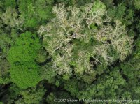
Here is an example of an image I took this past summer in Amazonian Ecuador flying my QP hexacopter from a canopy tower. Look near the upper center of the pic for a white square, that was my launch pad and I am standing just above it. This tower is 150' up in the tree.

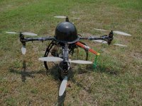
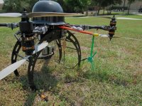
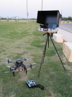
Here are some pics of my current X8. I have a build log over at RCG in the Hoverfly forum (hope you mods don't mind me linking to there): http://www.rcgroups.com/forums/showthread.php?t=1380528


Thanks in advance to all! Shawn
As requested I will fill you guys in on my background and intended uses for multirotor copters. Currently, I am a PhD candidate at Texas State University in the Department of Biology. My primary interest is in Batrachology (study of amphibians). I have been doing amphibian research in Amazonia since 2000. I am also Founder and President of a non-profit research organization for tropical amphibian research and conservation (www.tadpoleorg.org). My dissertation focuses on amphibians living in the high canopy tree tops of the Amazon. I am focused on the ecology, molecular ecology, and the affects of habitat degredation on the canopy amphibian communities that live in large epiphytic plants called bromeliads that are capable of holding large volumes of water. These plants literally create wetlands in the sky between 50-150+ feet up in the canopy. My main avenue for conducting these studies have been ground-based surveys and climbing these trees to sample the bromeliads using single-rope tree climbing techniques. For the longest time I have been wondering about how much easier it would be to do some of this work from an aerial platform. I have taken airplane flights over the forest to do some survey work and acquired satellite imagery but both have major limitations, primarily cost. That's what led me to multirotors a little over a year ago. For more on my research you can visit my little homepage, www.shawnmccracken.net.
I have never done anything RC before, but after discovering multirotor copters on the internet I realized they had serious potential for tropical forest canopy research. I purchased my first used quad flying the QP FC a little over year ago. I have now built a couple quads, hexas, and now an X8. My my intended use for this platform is to collect aerial imagery of tropical forest that can then be geo-rectified and used for GIS analyses. I would also like to collect HD video for amateur/scientific and possibly professional presentation of my work. I need a platform that is easily transported because of international travel and in-country transportation such as bus, hiking, canoe, etc. I also desired as small a frame diameter as possible since I will often be launching/landing from trees or canopy towers in forested areas. This is why I have chosen the X8 (coax octo) platform. I also wanted/needed redundancy since I won't have a backup. I am hoping I can get enough flight time out of it so I can shoot several hectares in a flight. I plan to use a Panasonic GH2 for much of the work, but will also be flying a modded Canon t2i for NDVI imagery (multispectral) and in the future a full-blown multispectral scanner and FLIR system.
I currently fly the X8 with the HoverflyPro board which does fairly well. I want a silky smooth X8 with full gps navigation abilities so at the end of the month I will be purchasing a full MK electronics setup to install. I look forward to getting all the help I can from this great community.
Here is an example of an image I took this past summer in Amazonian Ecuador flying my QP hexacopter from a canopy tower. Look near the upper center of the pic for a white square, that was my launch pad and I am standing just above it. This tower is 150' up in the tree.
Here are some pics of my current X8. I have a build log over at RCG in the Hoverfly forum (hope you mods don't mind me linking to there): http://www.rcgroups.com/forums/showthread.php?t=1380528
Thanks in advance to all! Shawn
Attachments
Last edited by a moderator:
")