Tersus RTK Engineer
Member
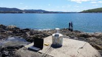
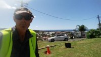
Precis RTK system is being used for some pretty cool stuff. Mr. Stephen Noble, owner of Drone Surveying, used Precis RTK boards to provide land survey and aerial photography service in Australia. By leveraging L1/L2 GPS frequencies for accuracy and reliability, when fixed in RTK or PPK mode, their equipment provides centimeter absolute accuracy. Check it out.
Contact Us, click here.


Contact Us, click here.