In the log creted in the fly with pics downloaded from your IOSD MK2 to your PC, then export with GPSexporter and you can obtain a log with the gps info
thanks a lot leofuica
i was confused. I will try it!
In the log creted in the fly with pics downloaded from your IOSD MK2 to your PC, then export with GPSexporter and you can obtain a log with the gps info
pls4air:
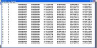
I used sucessfull a Photogrametric DJI tools, geotagging, acctitude in each photo, altitude, latitude and longuitude every pics fine, great for work in 3D, point cloud, etc etc.
I trigger my camera NEX 5N trough the WK (with action setting) in real and simulate mode with out problem, maybe your not follow all the instruction because the DJI manual is very strange and short, but with hard work i have all the potencial of WK GS, and beleave me, is powerfull than others like APM 2.6
Hello Leofuica,
I've been following this information for a while. Thanks a bunch for your detail description. You state that you can only use the F1 port for photos? What about if your running SBUS ? Can you use the other ports out? Will WKM / IOSD2 Record it?
Leofuica have you compare the precision of the wookong gps vs another GPS logger in the aircraft.? I use the gps telemetry module of the futaba radio and it has the same presicion of a Garmin navigator.
Thanks in advance